Birding Montrose Point
Montrose Glossary
- Beach House
- The blue and white building adjacent to Montrose Beach.
- Boatyard
- The large, fenced parking lot just north of the harbor. Used to store boats in the winter.
- Butterfly Garden
- The field northwest of the Magic Hedge planted in native wildflowers to attract butterflies.
- Chicago Corinthian Yacht Club
- The building at the north end of the harbor.
- Cricket Hill
- The grassy hill east of Lake Shore Drive and northwest of Montrose Harbor.
- Cruising
- The practice of looking for casual sex by gay men.
- Dog Area
- The fenced-in area at the far west end of Montrose Beach where dogs can run unleashed.
- Fishing Pier
- The fishhook-shaped pier that extends north into Lake Michigan from the east end of Montrose Beach.
- Fluddle
- A pool of water that forms on Montrose Beach after a heavy rain or strong northeast winds push water onto the beach. When a fluddle is very large and covers most of the beach we refer to it as Lake Montrose.
- Golf Course Pond
- The small pond just west of Montrose Harbor at the north end of the Sydney R. Marovitz Golf Course.
- Magic Hedge
- The line of shrubs and trees that runs southwest to northeast from the northeast corner of Montrose Harbor. So called because of its "magical" power to draw in passerines and other landbirds.
- Montrose Beach
- The broad sandy beach that extends from the Fishing Pier to West Lawrence Avenue. Divided into 3 parts, the public beach, the protected beach, and the dog area. The public beach is west of and outside the Dunes and the protected beach is inside the fence. The dog area is at the far west end of the beach.
- Montrose Dunes
- The complex habitat of beach vegetation at the east end of Montrose Beach.
- Montrose Harbor
- The large boat harbor on the south side of Montrose Point. The mouth of the harbor forms the southern boundary of Montrose Point in the Birding Montrose Point guide.
- Montrose Point Bird Sanctuary
- The part of Montrose Point that includes the Magic Hedge, Meadow, and peripheral plantings.
- Montrose Regular
- A regular and frequent birding visitor to Montrose.
- Native Planting Area
- The area of native flowers on the south and east sides of Montrose Point.
- Panne
- The shallow water wetlands in the Dunes. Currently there are two – an east panne and a west panne.
- Park Bait Shop
- The fishing and tackle store at the corner of W. Montrose Avenue and W. Montrose Harbor Drive.
- Peripheral Plantngs
- The trees and shrubs between the Magic Hedge and Meadow and the Native Planting Area and Dunes.
- Protected Areas
- Any area that's fenced or cordoned off with rope. Entry into these areas is prohibited. An area may be fenced or cordoned off to protect plantings or to discourage cruising.
- Sydney R. Marovitz Golf Course
- The large golf course bounded by North Lake Shore Drive on the west, Lake Michigan on the east, West Montrose Avenue on the north, and Waveland Avenue on the south.
- The Meadow
- The open grassy area east of the Magic Hedge.
- The Steps
- The stone steps that lead down to the concrete walking path that borders the south side of the Dunes. There are two sets of steps, one due north of the Magic Hedge and the other further east near the base of the fishing pier.
- Water Feature
- The small ground fountain about 50 yards east southeast of the Magic Hedge. The water feature runs in spring, summer, and fall.
- Wilson Avenue Boat Launch
- The small enclosure at the north end of Montrose Beach, formerly used as a boat launch.
- Wilson Avenue Crib
- The large structure on Lake Michigan due east of Montrose Point. The Wilson Avenue Crib was part of the water distribution system for Chicago. It is no longer operational but it does host nesting Double-crested Cormorants.
Aerial Photo of Montrose Point*
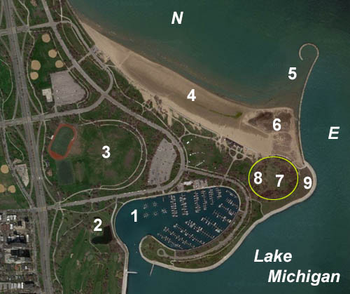
- 1) Montrose Harbor
- 2) Golf Course Pond
- 3) Cricket Hill
- 4) Montrose Beach
- 5) Fishing Pier
- 6) Montrose Dunes
- 7) The Meadow
- 8) Magic Hedge
- 9) Native Planting Area
Note: The yellow circle in the above map delineates the Montrose Point Bird Sanctuary.
*Courtesy of the United States Geologic Survey